
Earthquake Risk
One of the main goals of the earthquake risk project of CEDIM is asses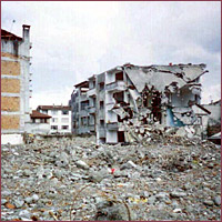 sment and mapping of the risk for all Germany. The first stage of the work is dedicated to analyses of potential direct losses due to structural damage to the existing residential building stock.
The risk is calculated from (1) intensity-based probabilistic seismic hazard, (2) structural vulnerability models constructed for the residential building stock of communities and (3) distribution of assets in terms of replacement costs for residential buildings. In parallel with the probabilistic hazard-map-based approach the deterministic scenario-based approach is used. The developed models are calibrated and validated with the use of observed data from several damaging earthquakes in Germany and the nearby area.
The planned activities include, inter alia, consideration of other probable direct and indirect losses, industrial and public buildings, infrastructure in earthquake prone areas.
Project description
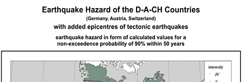
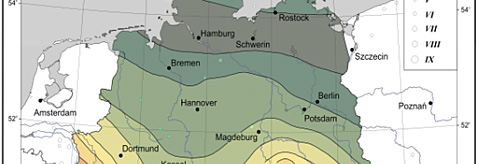
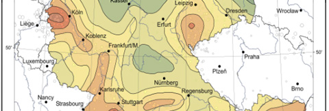
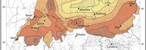
The level of seismic hazard in Germany is, in a global sense, low, but not negligible. The level of seismic hazard in Germany is, in a global sense, low, but not negligible. There are several earthquake prone regions in the country, which have produced Mw magnitudes above 6 and intensities up to VIII. Larger earthquakes in future cannot be ruled out. The distribution of seismic hazard in Germany (as well as in Austria and Switzerland) is presented by the so-called D-A-CH map (Grünthal et al, 1998) (https://www.gfz-potsdam.de/pb5/pb53/projects/en/dach/menue_dach_e.html) (Figure 1), where the hazard is given in terms of EMS macroseismic intensities for a non-exceedance probability of 90% within 50 years (corresponding to a mean return period of 475 years).
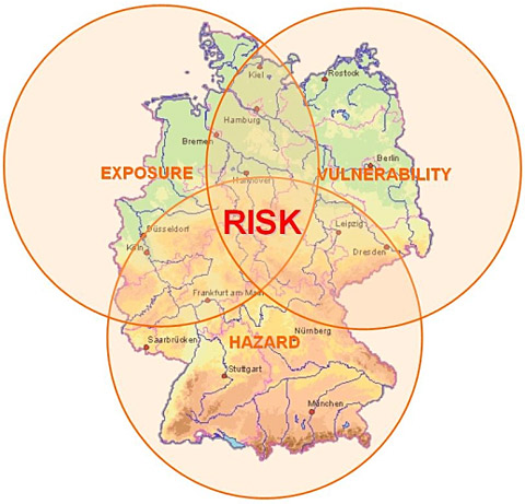
It should be taken into consideration that the level of risk (potential losses) depends not only on the level of hazard, but also on the elements at risk located in the hazard prone areas, including their value and vulnerability (Figure 2). And the level of risk is higher if the hazard coincides with higher concentration of exposed assets. Therefore the risk analysis and risk management should include consideration of all relevant factors contributing to the risk level.
Strong earthquakes can influence different aspects of society’s life. Correspondingly, the risk estimates can be described in the form of structural damage to buildings and structures, social (injured and killed people) or economic (monetary losses) impacts. The currently obtained estimates of seismic risk for Germany take into consideration only primary economic losses due to structural damage to residential buildings.
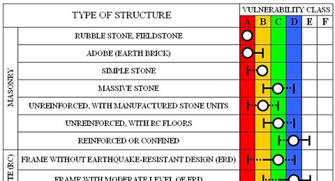
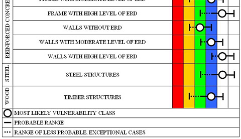
The residential building stock of communities in Germany consists of different types of buildings. The vulnerability analysis is conducted in terms of the EMS-98 (Grünthal, 1998) (https://www.gfz-potsdam.de/pb5/pb53/projects/en/ems/menue_ems_e.html), where six vulnerability classes are introduced, denoted alphabetically from A (highest vulnerability) to F (lowest vulnerability), to describe performance of different types of buildings under seismic influence (Table 1). The vulnerability classes A to D are those representing the residential building stock in Germany.
In the frame of the developed large-scope approach, which is aimed at mapping of risk for the whole country, the administrative units (communities) or their parts (postcode areas) are considered as the cells of the computational grid. In the frame of the approach the interest is rather the vulnerability composition of the existing building stock than the seismic performance of single buildings. Therefore, the principal core of the developed methodology is modelling of the vulnerability composition of the existing building stock of communities. The vulnerability composition is understood as the percentage of buildings corresponding to different vulnerability classes in a community.
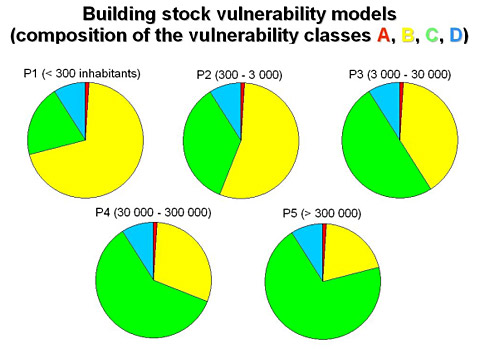
The vulnerability composition is different in different communities. At the same time the conducted analyses show that the building stock of larger communities (urban areas) is generally characterized by a less vulnerable composition of the building stock than that of smaller communities (rural areas). The found consistent regularity was used for developing representative vulnerability composition models for communities.
The whole family of 13490 communities of the Germany was assigned into five classes, depending on the number of inhabitants. For each of the community classes the vulnerability composition models describe the building stock in terms of the EMS-98 vulnerability classes (Tyagunov et al, 2006) (https://www.nat-hazards-earth-syst-sci.net/6/573/2006/nhess-6-573-2006.pdf). The vulnerability composition models presented in Figure 3 were used for damage and risk analyses in the study.
The estimates of assets are obtained by the Asset Estimation Group of CEDIM (Kleist et al, 2006) (https://www.nat-hazards-earth-syst-sci.net/6/541/2006/nhess-6-541-2006.pdf) and quantified in terms of replacement costs for residential buildings for the reference year 2000. The total asset values in a community depend on the number of inhabitants and vary considerably from small villages (order of millions of Euro) to large cities (order of many billions of Euro).
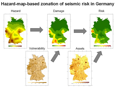
For estimation of probable damage and losses from potential future earthquakes the hazard, vulnerability and asset data are integrated on a GIS platform. Combining the hazard input with distribution of communities of different classes and corresponding vulnerability models, the distribution of probable damage to the residential building stock is obtained. Further, combining the damage estimates with the asset values, the corresponding losses are obtained (Figure 4).
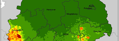
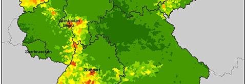
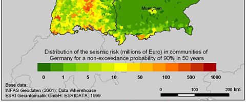
The computations are conducted for all 13490 communities of Germany, resulting in a map (Figure 5), which shows spatial distribution of seismic risk in the country. The level of potential losses in different communities varies from zero to hundreds of millions of Euro. There is no risk in the areas with the expected level of seismic intensity V or less, which causes no damage to buildings. No risk exists in uninhabited areas, where there are no asset values. On the contrary the highest level of risk is generated by combination of a higher hazard level and a higher concentration of exposed assets.
It should be emphasized that the obtained estimates correspond to the hazard level of a non-exceedance probability of 90% in 50 years (a mean return period of 475 years). The damage and loss estimates would change for other hazard levels.
In parallel with the probabilistic mapping of seismic risk the approach can be applied for the deterministic earthquake scenarios to estimate the level of damage and losses from single seismic events.
More detailed description of the approach as well as some additional results obtained by the earthquake team of CEDIM can be found in the article of Tyagunov et al (2006) (https://www.nat-hazards-earth-syst-sci.net/6/573/2006/nhess-6-573-2006.pdf).
Publications
| Tyagunov S., D. Hollnack, F. Wenzel | Geo-modelling and analysis of site effects in the area of Cologne | Proceedings of the Conference "Skopje Earthquake - 40 Years of European Earthquake Engineering", Macedonia, Ohrid, 2003 |
| Tyagunov S., D. Hollnack und F. Wenzel | Risiken durch Sekundäreffekte von Erdbeben | Deutsches Forschungsnetz Naturkatatrophen (DFNK) Abschlussbericht. Eds. B.Merz, H.Apel. GeoForschungsZentrum Potsdam, 2004. 179-187 |
| Tyagunov S., Stempniewski L., Grünthal G., Wahlström R., and Zschau J. | Seismic vulnerability and risk analysis at a national scale: Methodology and preliminary results for Germany. | Proceedings of the 3rd International Conference on Continental Earthquakes (III ICCE), Beijing, China, 12-14 July, 2004 |
| Wahlström R., Tyagunov S., Grünthal G., Stempniewski L., Zschau J., and Müller M. | Seismic Risk Analysis for Germany: Methodology and Preliminary Results | Disasters and Society - From Hazard Assessment to Risk Reduction. Logos-Verlag, Berlin, 2004 |
| Tyagunov S., Stempniewski L., Grünthal G., Wahlström R., and Zschau J. | Vulnerability and risk assessment for earthquake-prone cities | Proceedings of the 13th World Conference on Earthquake Engineering, Vancouver, BC, Canada, 1-6 August, 2004. |
| Tyagunov S., Stempniewski L., Grünthal G., Wahlström R., Zschau J., and Müller M. | CEDIM: An approach to the regional-scale analysis of seismic risk | Proceedings of the International Conference "Problems of Seismic Hazard and Seismic Risk Estimation and Earthquake Forecasting", Tashkent, Uzbekistan, 7-8 October, 2004. (in Russian) |
| Tyagunov S., Stempniewski L., Grünthal G., Wahlström R., and Zschau J. | Vulnerability and Risk Analysis for Earthquake Prone Communities | Proceedings of IABSE Symposium on Structures and Extreme Events, Lisbon, September 14-16, 2005, IABSE Report, Vol.90. |
| Tyagunov, S., Heneka, P., Stempniewski, L., Zschau, J., Ruck, B. and Kottmeier, C. | CEDIM: From Multi-Hazards to Multi-Risks | Proceedings of the 1st ARMONIA conference, Barcelona, December 2005 |
| Tyagunov S., Grünthal G., Wahlström R. Stempniewski L., & Zschau J. | Seismic risk mapping for Germany | Natural Hazards and Earth System Sciences. Special Issue: Methods for risk assessment and mapping in Germany, 6, 2006, 573-586 |
| Kleist, L., Thieken, A. H., Müller, M., Seifert, I., Borst, D., and Werner, U. | Estimation of the regional stock of residential buildings as a basis for comparative risk assessment for Germany | Natural Hazards and Earth System Sciences. Special Issue: Methods for risk assessment and mapping in Germany, 6, 2006, 541-552 |
| Tyagunov S., Hollnack D., and Wenzel, F. | Engineering-Seismological Analysis of Site Effects in the Area of Cologne | Natural Hazards, 38, 2006, 199-214 |
| Grünthal, G., Thieken, A.H., Schwarz, J., Radtke, K.S., Smolka, A., Merz, B. | Comparative Risk Assessments for the City of Cologne - Storms, Floods, Earthquakes | Natural Hazards, 38, 2006, 21-44 |
| Tyagunov S., Grünthal G., Wahlström R., Stempniewski L., Zschau J. und Münich Ch. | Erdbebenrisiko-Kartierung für Deutschland | Beton- und Stahlbetonbau, 101 2006, Heft 10, 769-782 |
Links
Earthquake Engineering Research Center, University of California, Berkeley
https://eerc.berkeley.edu/
Earthquake Engineering Research Institute (EERI)
https://www.eeri.org/
European-Mediterranean Seismological Centre
https://www.emsc-csem.org/
European Seismological Commission
https://www.esc.bgs.ac.uk/
European Strong-Motion Database
https://www.isesd.cv.ic.ac.uk/
GeoHazards International (GHI)
https://www.geohaz.org/
Geophysical Survey of Russian Academy of Sciences (GSRAS)
https://www.ceme.gsras.ru/new/eng/ssd_news.htm
Incorporated Research Institutions for Seismology (IRIS)
https://www.iris.edu/
International Association of Seismology and Physics of the Earth's Interior (IASPEI)
https://www.iaspei.org/
Multidisciplinary Center for Earthquake Engineering Research (MCEER)
https://mceer.buffalo.edu/
Observatories and Research Facilities for EUropean Seismology (ORFEUS)
https://orfeus.knmi.nl/
Seismological Society of America
https://www.seismosoc.org/
Seismo-surfing the Internet for Earthquake Data
https://www.geophys.washington.edu/seismosurfing.html
Swiss Seismological Service
https://www.seismo.ethz.ch/
United States Geological Survey (USGS)
https://www.usgs.gov/