
Wildland-urban interface (WUI) and forest fire vulnerability in Brandenburg
Progressing climate change causes higher temperatures and declining precipitation rates in the spring, summer, and autumn months, increasing the risk of forest fires in Germany. In 2018, 2019, and 2022, forest fires were widespread and burned large areas, indicating that they might become a more important issue for Germany in the near future. Currently, the increased risk and the occurrence of large forest fires are contrasted by a lack of knowledge that exists among forest practitioners, forest owners, firefighters, and other recognized security institutions. To prepare for upcoming extreme events, it is critical to identify and delimit areas and settlements where problems related to forest fire hazard and a lack of knowledge are by far the most relevant, namely the wildland-urban interface (WUI). The WUI is known as the contact zone where wildland or forest vegetation meets or mixes with human infrastructure.
Within the framework of a master’s thesis and in close collaboration with CEDIM, a comprehensible workflow was developed to identify and characterize the WUI in Brandenburg (NE Germany). Assuming that the WUI in Brandenburg is predominantly associated with forest fire ignition through human activity, Generalized Additive Models and the Random Forest algorithm were used to analyze the influence and importance of different anthropogenic infrastructure variables on forest fire occurrence. Based on the results, the combination of buildings and drivable roads were defined as the WUI-relevant infrastructure component.
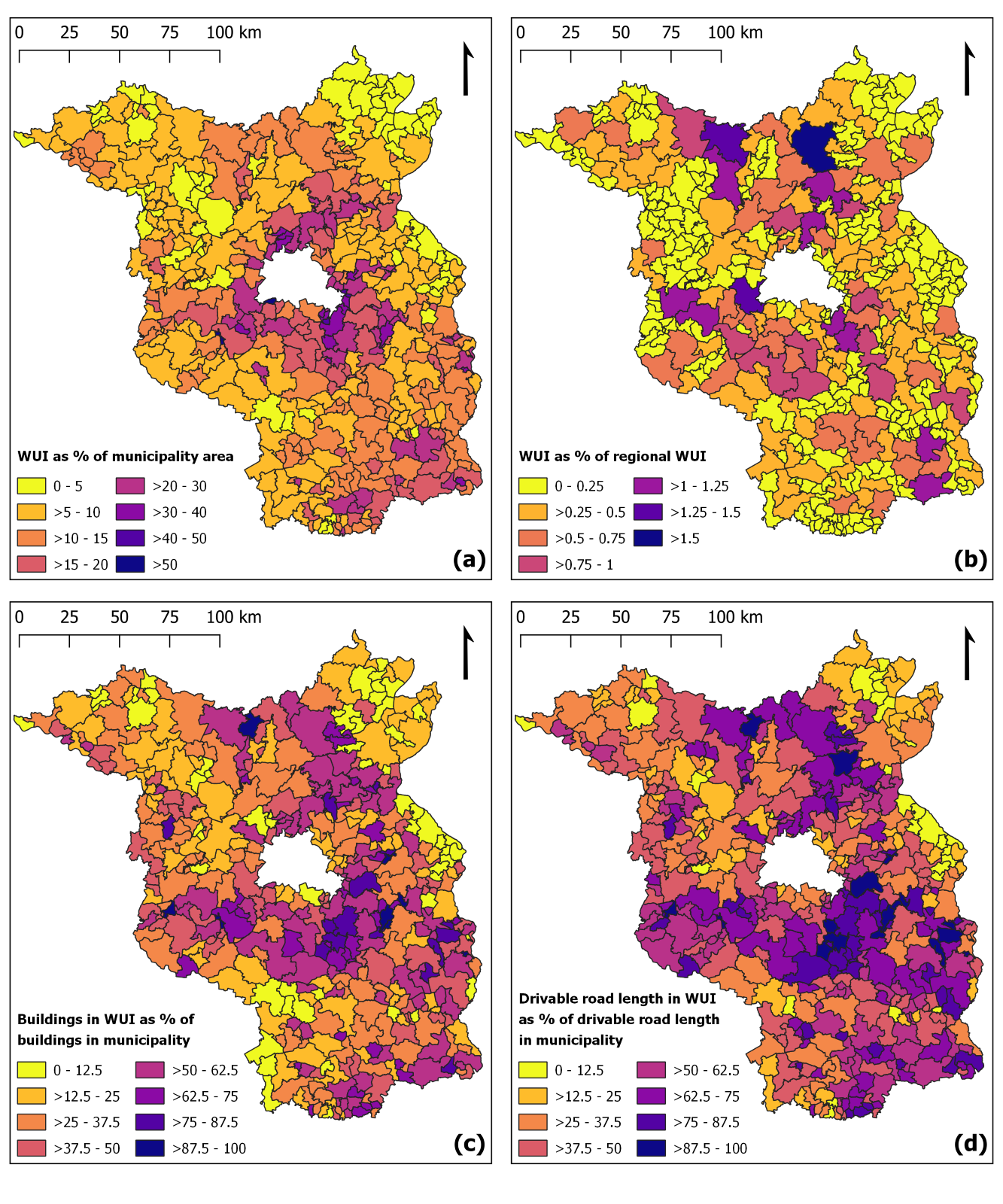
An analysis of empirical cumulative distribution functions (ECDFs) of the percentage of forest fire occurrence points arising at increasing distances from selected WUI-relevant infrastructure confirmed the existence of a spatial clustering of forest fire occurrences and indicated that the cumulative distribution of the distances of fire occurrences to infrastructure is comparable to Portugal. Consequently, an existing Mediterranean framework was adopted to map the WUI in Brandenburg. Subsequent WUI mapping revealed that 10.7% of Brandenburg’s area and more than one-third of its buildings are located in the WUI. Figure 1 shows four different maps that characterize the WUI in the 416 municipalities of Brandenburg. WUI hotspots are located in the rural district Potsdam-Mittelmark, southwest of Berlin.
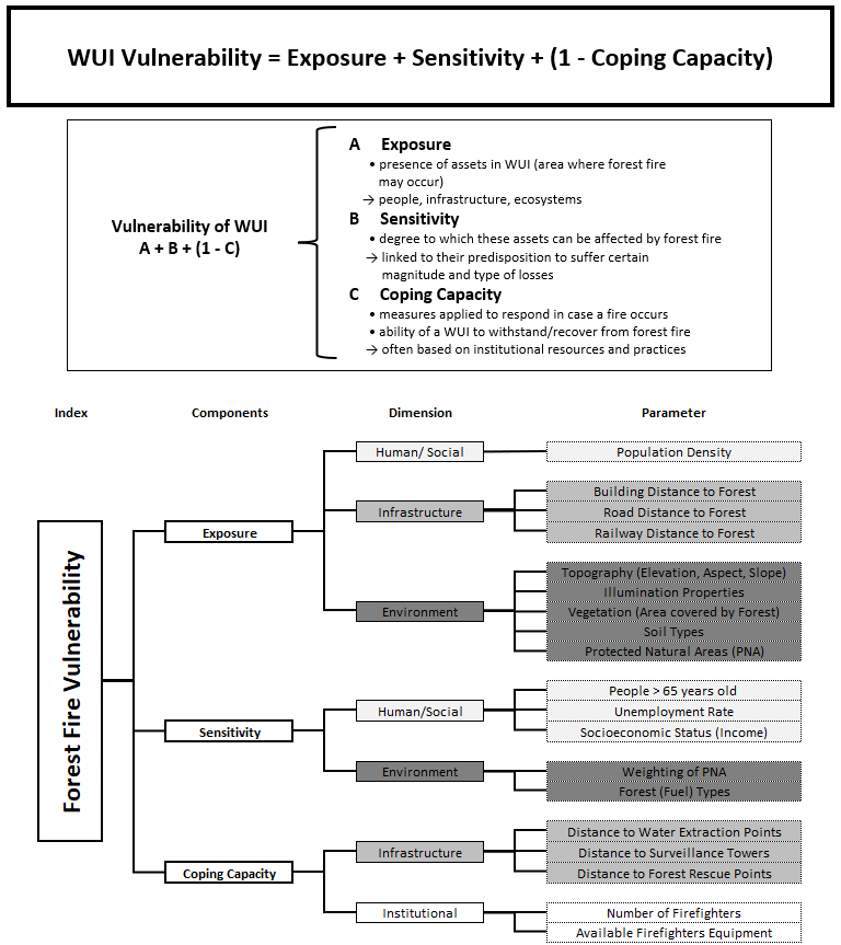
In a second step, an assessment framework was introduced to gain an understanding of the WUI forest fire vulnerability. The WUI forest fire vulnerability was defined as the propensity of the WUI to suffer damage when a forest fire occurs and the introduced framework considers several parameters based on exposure, sensitivity, and coping capacity elements (cf. Figure 2). Focusing on the environmental exposure component, Monte Carlo simulations were applied to test the forest fire selectivity of six landscape characteristics in adjacent areas of the WUI. Forest vegetation classes, explosive ordnance contamination, and soil types showed distinct selectivity patterns regarding forest fire frequency. The results of the fire selectivity analysis were used to derive an index of the relative forest fire proneness. Areas with high forest fire proneness are characterized by pure pine stands on fine-sandy medium sand topsoil combined with explosive ordnance contamination.
The findings of the master’s thesis advance the knowledge on forest fires in Germany and provide a valuable baseline for future work and the development of prevention and mitigation strategies for reducing future forest fire risk and impacts.
Author: Johannes Brand (July 2023)
Title of the master’s thesis: Development of a Framework to Assess Forest Fire Vulnerability in Germany
Supervisors: Prof. Dr. Fabian Fassnacht & Prof. Dr. Michael Kunz
Associated institute at KIT: Institut für Geographie und Geoökologie (IFGG)